NEW MILLS TOWN TRAIL
Introduction
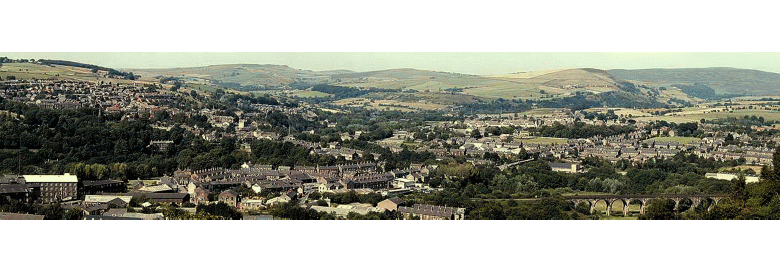
New Mills is in an area of spectacular natural beauty standing astride the river Goyt at its confluence with the river Sett. As the river Goyt leaves the Derbyshire Peak District and flows into Cheshire, it abandons its floodplain and takes an unusual route – a meandering course through a 100 ft deep sandstone gorge known as the Torrs, above which the town is sited. The origin of this gorge goes back to the last glacial period, 50,000 – 15,000 years ago, when ice filled the Irish Sea and Cheshire plain and pushed up into the valleys of the western Pennines. In the area around New Mills the ice reached up the valleys as far as Little Hayfield, Chapel-en-le-Frith and Barmoor Clough. The ground above about 1000-1200 ft remained uncovered but frozen.
The winding gorge, cut by glacial melt water, provided sites within its bends for the early cotton mills and the steep gradient of the river with waterfalls and cascades allowed the construction of weirs and leats and the provision of water power. The sides of the gorge are formed of sandstone, which has proved a valuable building stone for the mills, bridges and buildings in the town.
The town takes its name from a medieval corn mill which was located on the river Sett at the bottom of High Street. Sometime after 1391 it became known as "newmylne" (it had been rebuilt) and by the late sixteenth century the name New Mill was in use as a place name for the little hamlet, which had grown up around the mill. When the cotton mills arrived in the 1780s-1790s a new town grew up on the farmland above the Torrs gorge and became known as New Mills. The resulting community is a closely knit one, grown out of an amalgam of long established families going back many centuries, families who trace their beginning from those who came to the town as its industries grew up in the nineteenth century, and those who have come to to live in the town much more recently. As a result, a great many are inter-related, so much so that it is said 'Kick one and they all limp'.
New Mills has an extensive conservation area which has contributed to preserving and enhancing the architectural heritage and character of the town's public buildings, shops, and houses. Over the years, since the first Local Board was established in 1876, a number of important buildings and other assets have been provided by public subscriptions or by the local rates. These include the Town Hall, High Lee Hall and its park, the first Library and Reading Room, Union Road Bridge, the Swimming Pool, the Heritage Centre, the Church of St James and Art Centre, the Torrs Riverside Park, the Millward Memorial Bridge, and the Millennium Walkway. Despite the impact of out-of-town superstores, there are over eighty shops, all but a handful still independent traders supported by loyal customers who epitomise the appreciation and closeness of community values.
1. Start the trail at New Mills Heritage Centre
The Heritage Centre stands at the top of one of the paths leading down into the Torrs. From the viewing platform there is a view of Torr Vale Mill, the river Goyt and its weir. Note the information board about Torr Vale Mill here. The centre was opened in 1988 and includes a shop selling publications, maps and trails; fixed display areas telling the "New Mills story"; and a unique model of the town in 1884 with an accompanying sound and light commentary. The centre is also a fully registered museum.
2. Turn right out of the centre and walk up the path to the bollards in front of the bus station and turn left onto Rock Mill Lane. Look over the wall to see another view of Torr Vale Mill and the railway passing under the town.
In 1841, the developer who built the Crown Hotel on Market Street also owned a large meadow stretching from Market Street to the cliffs of the Torrs. At the top of this meadow an outdoor market and a fairground were established. In the 1860s this part of the meadow called the "market ground" was bought by a railway company when two tunnels were constructed beneath it. The development of Union Road after the bridge was opened in 1884 reduced the size of the market. Since the 1970s it has been a bus station now leased by Derbyshire County Council from the railway company.
3. Turn left at the main road and after a few yards bear left down Station Road.
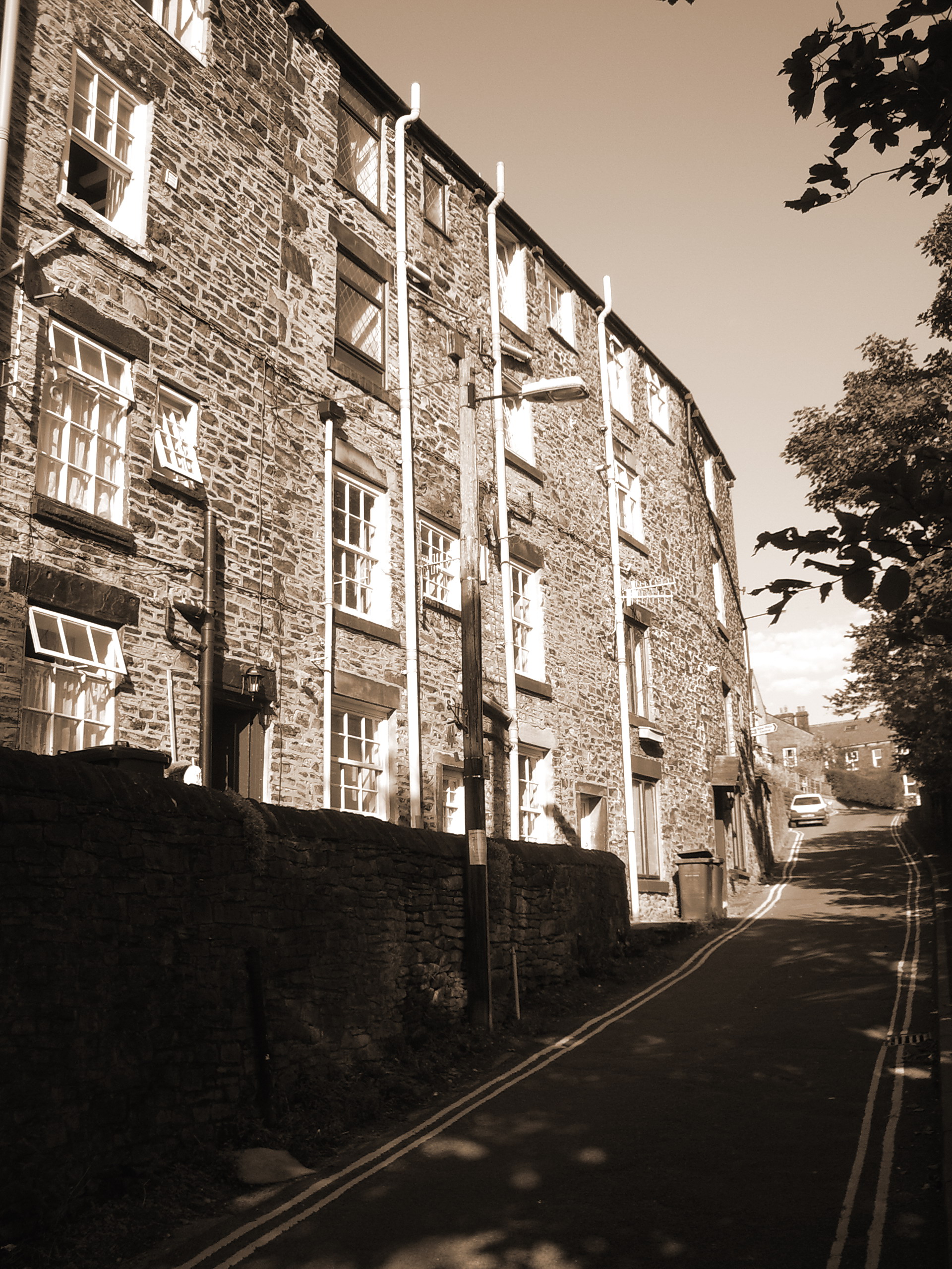 Before reaching Central Station, on the right are the "under-livings" of a terrace of houses dating from 1853. They have two storeys at the front on the main road and four storeys at the rear on Station Road. This is typical of many houses in New Mills with its steep slopes immediately above the rivers. Before reaching Central Station, on the right are the "under-livings" of a terrace of houses dating from 1853. They have two storeys at the front on the main road and four storeys at the rear on Station Road. This is typical of many houses in New Mills with its steep slopes immediately above the rivers.
4. Cross the bridge over the railway and walk onto the station platform
Central Station is the original building dating from 1865; note the station house and date stone. It was built by the Manchester, Sheffield and Lincolnshire Railway on their line to Hayfield. The Midland Railway route from Derby and London joined here in 1867, and from Sheffield in 1894. From the platform, note the portals to two tunnels under the town in the rock face – left hand tunnel to Hayfield (closed 1970), right hand tunnel to Sheffield.
5. Return to the road and take the steep footpath opposite marked "Millennium Walkway".
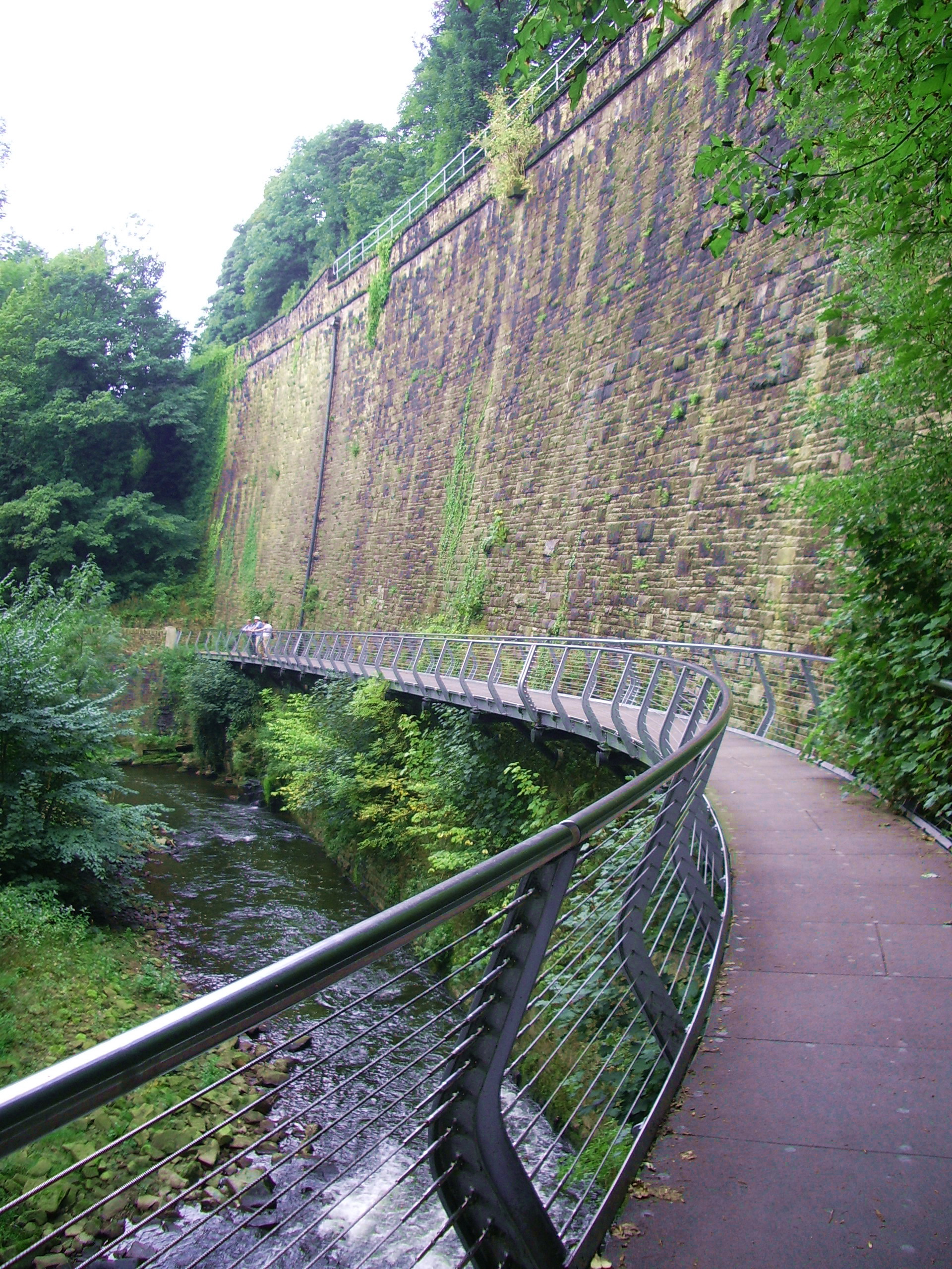 At the bottom, turn left.Work began in June 1999 to construct a 175-yard long elevated steel walkway, to span the otherwise inaccessible cliff wall above the river Goyt. Proposals for a link in the gorge’s footpath network, which include the Midshires Way and the Goyt Way, went back many years. But difficulties of access to the site severely hampered the planning and the breakthrough only came when Derbyshire County Council proposed the walkway as a millennium project funded from the national lottery and other private and public contributors. Opened in December 1999, the £550,000 walkway won nummerous awards, including the overall winner of the 2000 British Construction Industries Best Small Project Award, and featured on national BBC1 TV as an example of lottery funding. The project also featured on a 44p Post Office stamp marking the millennium. At the bottom, turn left.Work began in June 1999 to construct a 175-yard long elevated steel walkway, to span the otherwise inaccessible cliff wall above the river Goyt. Proposals for a link in the gorge’s footpath network, which include the Midshires Way and the Goyt Way, went back many years. But difficulties of access to the site severely hampered the planning and the breakthrough only came when Derbyshire County Council proposed the walkway as a millennium project funded from the national lottery and other private and public contributors. Opened in December 1999, the £550,000 walkway won nummerous awards, including the overall winner of the 2000 British Construction Industries Best Small Project Award, and featured on national BBC1 TV as an example of lottery funding. The project also featured on a 44p Post Office stamp marking the millennium.
Visitors are able to inspect close at hand one of the most remarkable stone retaining walls to be seen anywhere (built in the 1860s). The walkway provides a spectacular attraction and a direct route through this historic gorge for the thousands of walkers and visitors who come here every year. And for many local people who have been unable to negotiate the steep slopes and steps on the existing footpaths, it offers a level, wheelchair-friendly path through this heritage rich area. It also provides another route for visitors to reach the town’s Heritage Centre.
6. Halfway along the walkway stop to look at Torr Vale Mill.
Torr Vale Mill is a complex of buildings dating from the late 1780s, when Daniel Stafford the local corn miller used his millwright expertise to build a small cotton mill. The complex was originally water-powered with two large water wheels in the basement of the largest building. In the 1860s, when the mill was extended and partly rebuilt, a steam engine was installed which was run coupled with the water wheels. Above the impressive weir, an iron sluice gate marks the entrance to the headrace, which carried water to the water wheel. In the 1940s, gas and electricity became the sources of heat, steam and power. The mill closed in 2000. It had been in use for over 200 years making it the longest continuous mill manufacturing site in England. It has been graded II* by English Heritage.
At the end of the walkway, is the site of Rock Mill, which occupied an extensive site within a bend of the river Goyt. Built around 1790 by the John Crowther as water powered cotton spinning mill. Known as Crowther Mill it changed hands, ownership and production many times. In 1829 it was refitted as a printworks. At this time a steam engine, boiler and dye houses were added, greatly expanding the premises. The name Rock Mill appears around 1840. In 1872 production switched to paper. The mill was abandoned around 1884 and fell into disrepair. Engine beds, fragments of walls and other remains can be seen around the site. There is an ancient weir in the river.
Opposite is Torr Vale Mill, built around 1788 by Daniel Stafford. And known as Stafford’s Mill. The mill was originally water powered. Above the impressive weir, can be seen an iron sluice gate marking the entrance to the headrace, which carried water to the two large water wheels. In 1856 when the mill was extended and partly rebuilt, a steam engine was installed. The water wheels were not removed, but instead harnessed to provide a combined system of power which operated until the 1940’s. After which electricity became the sole power source. The mill closed in 2000. It had been in use for over 200 years making it the longest continuous mill manufacturing site in England.
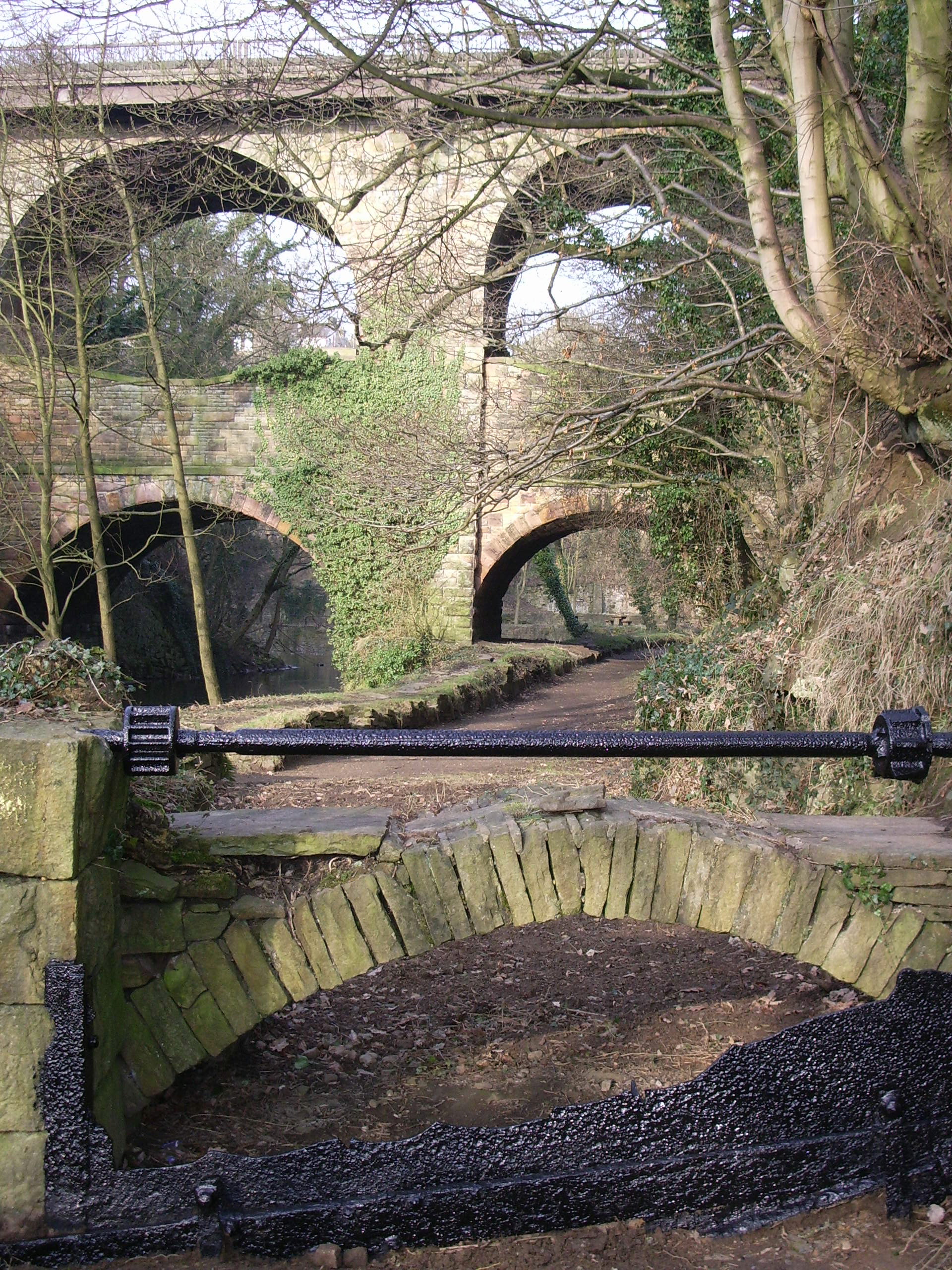
7. Follow the path until reaching Union Road Bridge, a viaduct of four arches.
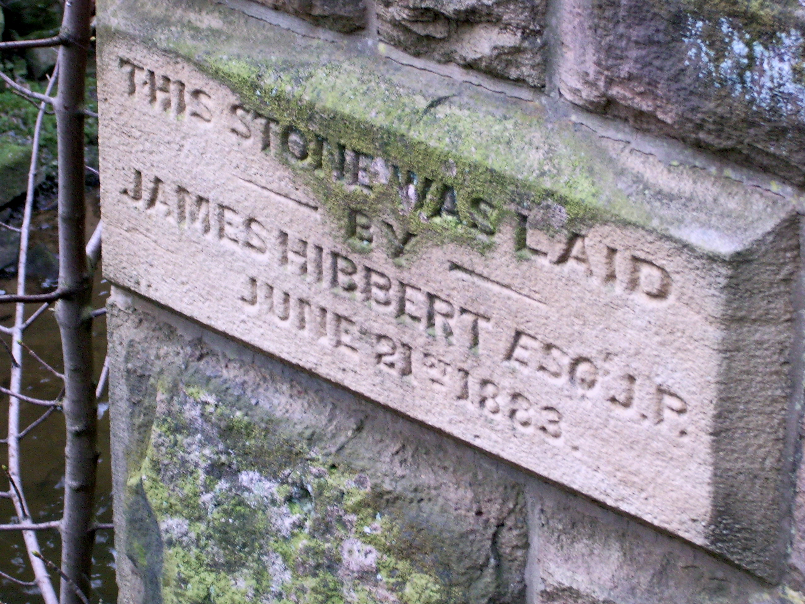 Note the sheer face of sandstone on the left, a former quarry.Before Union Road Bridge was built the only way to cross the Torrs Gorge was by the low level bridges. In 1875 a man was killed trying to cross and at the inquest the coroner was highly critical of the lack of proper bridges and roads. A high level bridge was certainly long overdue, for traffic from Newtown into New Mills had to take a circuitous route along Hyde Bank Road turnpike and pay tolls. Soon after the local board was formed in 1875, it received a petition from the ratepayers for a direct connection. The matter was a contentious one, chiefly because the cost of the bridge would be a charge on the rates and it was only by the casting vote of the chairman that the decision to build was taken. The contractor found that the stone of the Torrs was suitable for the construction of the bridge. 94 feet high, it was completed in nine months and was opened at a cost of £4,400. The procession at the opening was described as the largest ever seen in New Mills. Note the sheer face of sandstone on the left, a former quarry.Before Union Road Bridge was built the only way to cross the Torrs Gorge was by the low level bridges. In 1875 a man was killed trying to cross and at the inquest the coroner was highly critical of the lack of proper bridges and roads. A high level bridge was certainly long overdue, for traffic from Newtown into New Mills had to take a circuitous route along Hyde Bank Road turnpike and pay tolls. Soon after the local board was formed in 1875, it received a petition from the ratepayers for a direct connection. The matter was a contentious one, chiefly because the cost of the bridge would be a charge on the rates and it was only by the casting vote of the chairman that the decision to build was taken. The contractor found that the stone of the Torrs was suitable for the construction of the bridge. 94 feet high, it was completed in nine months and was opened at a cost of £4,400. The procession at the opening was described as the largest ever seen in New Mills.
8. Continue under the viaduct and turn right onto the footbridge to admire the view over the weir.
The confluence of the rivers Sett and Goyt can be seen from here as well as a good view of the double arched Church Road Bridge. Look up at the Union Road Bridge and note the 1884 date stone below the parapet. Walk back to the stone arch on the right, the original entrance to Torr Mill, and go down the steps and through the arch
This is the site of Torr Mill, built around 1790 by the Schofield family and known for much of its life as Schofield Mill. Unusually, although it had several tenants, the mill remained in the family throughout its life. In order to harness the waters of the fast flowing rivers in the gorge a series of weirs were built. The highest of these can be seen from the bridge. Torr Mill was originally driven by water carried along a leat and aqueduct from a weir upstream.
Following a fire in 1838, which caused substantial hardship among some local families; the mill was rebuilt and considerably extended.
At around that time a steam engine was added to the complex. The chimney standing against the rock face was completed in 1846. Cotton production on the site ceased in the 1890 and the machinery was removed. The building was in use by a Fustian (cloth) cutting firm when on the 2nd December 1912 a second fire, ‘The largest conflagration seen in New Mills’ completely destroyed the 5 storey mill.
The truncated chimney stands against the rock face of the gorge.
9. Walk through the picnic site and cross the wooden Millward Memorial Bridge over the river Sett.
The view from here sums up the various elements that make the Torrs unique – the low and high-level bridges, the weir, the remains of the mill, the rocky sides of the gorge and to the left, Church Road Bridge.In 1984, the New Mills Town Council took the opportunity of associating the centenary of Union Road Bridge with improvements to some environmental aspects of the Torrs, to make the area more accessible to the public. The main proposal, with the support of the County Council, was the erection of a new wooden footbridge across the river Sett, as a public memorial to the late Dr. Leslie Millward, who had led the campaign for opening up the Torrs in the late 1960s. Over £1,100 was subscribed to the appeal. The bridge was officially opened on 7th June 1984 immediately after the re-enacted procession exactly 100 years to the day after Union Road Bridge opened.
The new bridge provided a new path upstream to Goytside and thus completed a link with other paths in the Torrs such as the Sett Valley Trail and Goyt Way. The bridge stands on the site of a former aqueduct, which carried water to the wheel in Torr Mill. The former headrace or leat is followed by the path under Church Road Bridge.
10. Continue along the path under the bridge .
 Church Road Bridge was originally a two-arched bridge built in 1835 to carry the turnpike road from Newtown to Thornsett and Hayfield over the river Goyt. The lower tier and buttresses were inserted in 1888 to strengthen it; note the date stone above the lower arch. At the end of the path is the iron sluice gate, which controlled the flow of water from the river. From here note the weir and the view of the railway viaduct, built in 1902, crossing the river floodplain. Church Road Bridge was originally a two-arched bridge built in 1835 to carry the turnpike road from Newtown to Thornsett and Hayfield over the river Goyt. The lower tier and buttresses were inserted in 1888 to strengthen it; note the date stone above the lower arch. At the end of the path is the iron sluice gate, which controlled the flow of water from the river. From here note the weir and the view of the railway viaduct, built in 1902, crossing the river floodplain.
11. Retrace your steps across the Millward bridge and bear right, following the River Sett upstream passing the natural rock outcrops that give the Torrs its name. Immediately in front of you is a railway viaduct in stone and blue engineering brick.
This viaduct was built in 1867 by the Midland Railway as part of its line from London and Derby to Manchester via New Mills. In 1894 it was extended to Sheffield from Chinley. After crossing the river the line passes under the town by a tunnel, which comes out just before Central Station.
12. Take the path uphill to the viewing platform on the right at the top.
All supplies, including raw cotton and coal, needed by the mills in the Torrs had to be taken down the steep paths and finished goods brought back up. Horses were required to assist in hauling the carts up, and acting as a brake when taking them down. The open space here marks the site of the stables, a building that was demolished in the late 1970s owing to it being in a dangerous state.
The buttresses below Torr Top car park mark the site of a row of cottages, part of a community of early nineteenth century houses, which were built on the slopes right down to river level. The community was known as Bamford. The houses, were ill ventilated without proper sanitation or water supply, but were not demolished until the early 1960s.
13. Continue up the cobbled / setted road, noting the refurbished cottages on the left turning right into Torr Top Street, the original road to the Torrs.
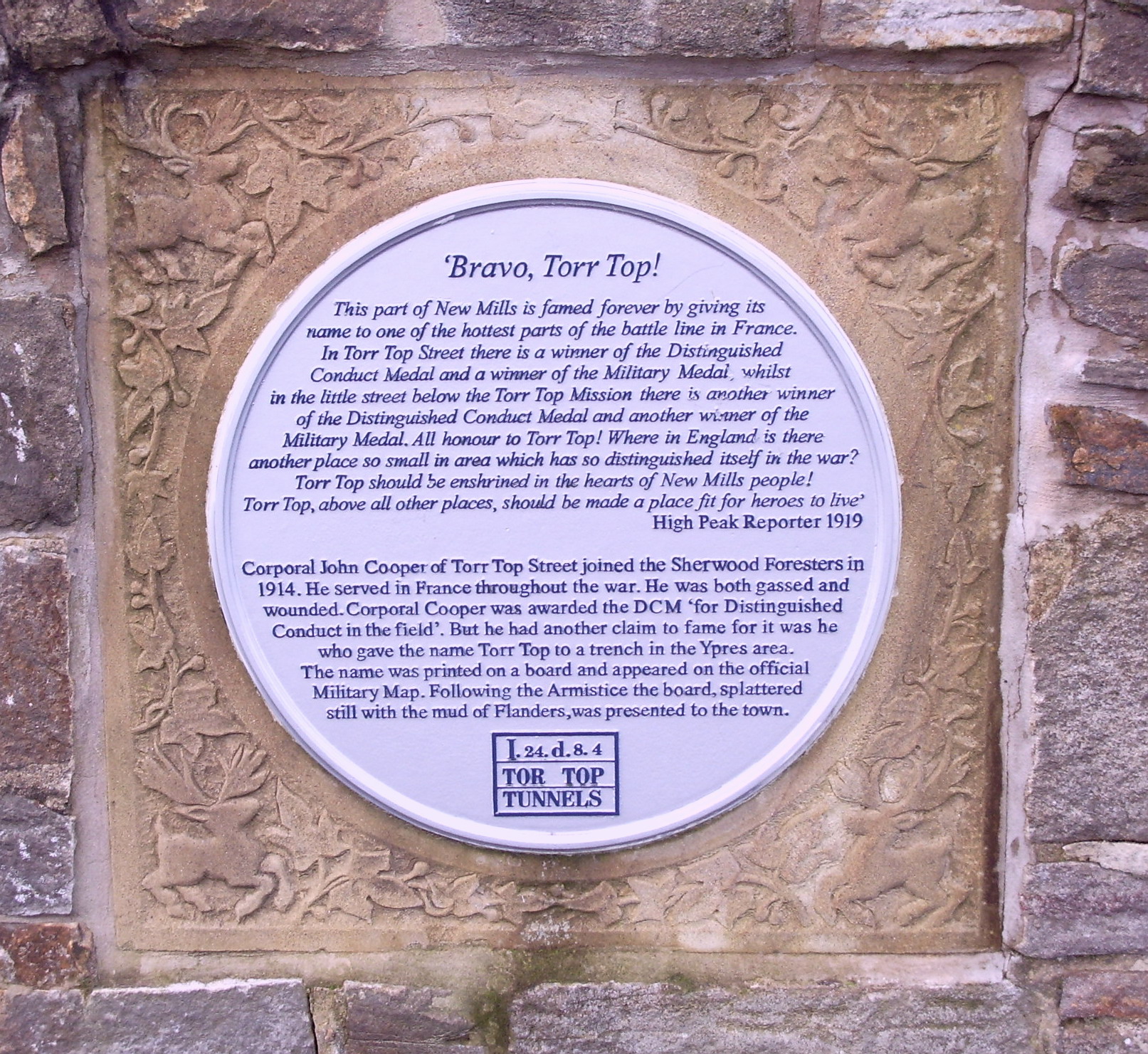 As you reach the top of the cobbled road a plaque commemorating the brave deeds of the men of Torr Top can be seen on the corner of Torr Top and Rock street. Several of the men mentioned, including Corporal John Cooper lived in the refurbished cottages you have just passed. As you reach the top of the cobbled road a plaque commemorating the brave deeds of the men of Torr Top can be seen on the corner of Torr Top and Rock street. Several of the men mentioned, including Corporal John Cooper lived in the refurbished cottages you have just passed.
Opposite Torr Top car park can be seen a preserved chimney. This is the oldest chimney in New Mills, dating from the late 1830s. It marks the site of Yates’ brass foundry, the remains of which, except for the chimney, were demolished in 1999 to make way for the houses.
14. Continue along Torr Top Street and at the end, turn immediately right into
Meal Street. Along Meal Street, on the right, note the chimney of Hyde Bank Mill, formerly Beard Mill, with a date stone 1868 and the initials M.T. referring to the then owner Marianna Thornley. The mill, rebuilt after a fire in the early nineteenth century, stands astride the river Sett on the site of an early woollen mill. In the early 1780s its woollen master, Thomas Beard, signified the changeover from wool to cotton by establishing here the first cotton-spinning factory in New Mills, next to his woollen mill. The mill has been converted to residential use.
Further along Meal Street is the elegant façade of the former George Hotel, dating from before the 1830s. After being derelict for several years, it was renovated in the 1990s with aid from the New Mills Conservation Area Partnership and converted into housing.
At the junction with High Street, there is a good view of the terraced housing, typical of many houses in New Mills, built on steep slopes above the river. With more storeys on the down slope side than on the road side, they are examples of split ownership. Note the entrances to the separate dwellings on the upper storeys.
 Opposite, the Mason’s Arms is a rebuild of an early New Mills public house. In the late 1820s, it was the terminus for the "Mercury" coach to Manchester. At the rear of the car park is a stone plaque with carved inscriptions in relief of tools of the mason’s craft. Opposite, the Mason’s Arms is a rebuild of an early New Mills public house. In the late 1820s, it was the terminus for the "Mercury" coach to Manchester. At the rear of the car park is a stone plaque with carved inscriptions in relief of tools of the mason’s craft.
Further down High Street on the right, the Christian Revival Church was formerly the earliest Wesleyan Chapel in New Mills. There is a date stone 1766 at the side of the building, but the present building is one rebuilt in 1844, hence the date stone on the front. It became too small for the congregation and in 1810 a new chapel, St. George’s Chapel, was built. The building here became the Day and Sabbath School.
On the left, all the waste ground rising steeply up to Spring Bank was, until the 1930s, an area of tightly packed cottages, built in the early 1800s for mill workers. It became known as Bankside, while adjacent to the Mason’s Arms was a separate group of cottages at right angles to High Street known as Spout Gutter. A surveyor’s report in the 1930s described the houses as having no damp courses, no through ventilation - they were built into the bank -and sharing one tap between seven houses. Most of them were demolished before 1939, but some remained until well after the war. Below these houses along the frontage of High Street was a row of shops as far as the Pineapple Inn. New housing has been built along this stretch of the road.
15. Continue to the bottom of High Street
The building on the corner of High Street is a former butcher’s shop – note the hooks outside on which meat was hung. There were several shops at the bottom of High Street, since demolished, and on Dyehouse Lane they have been converted into cottages. The Pineapple is the only pub surviving.
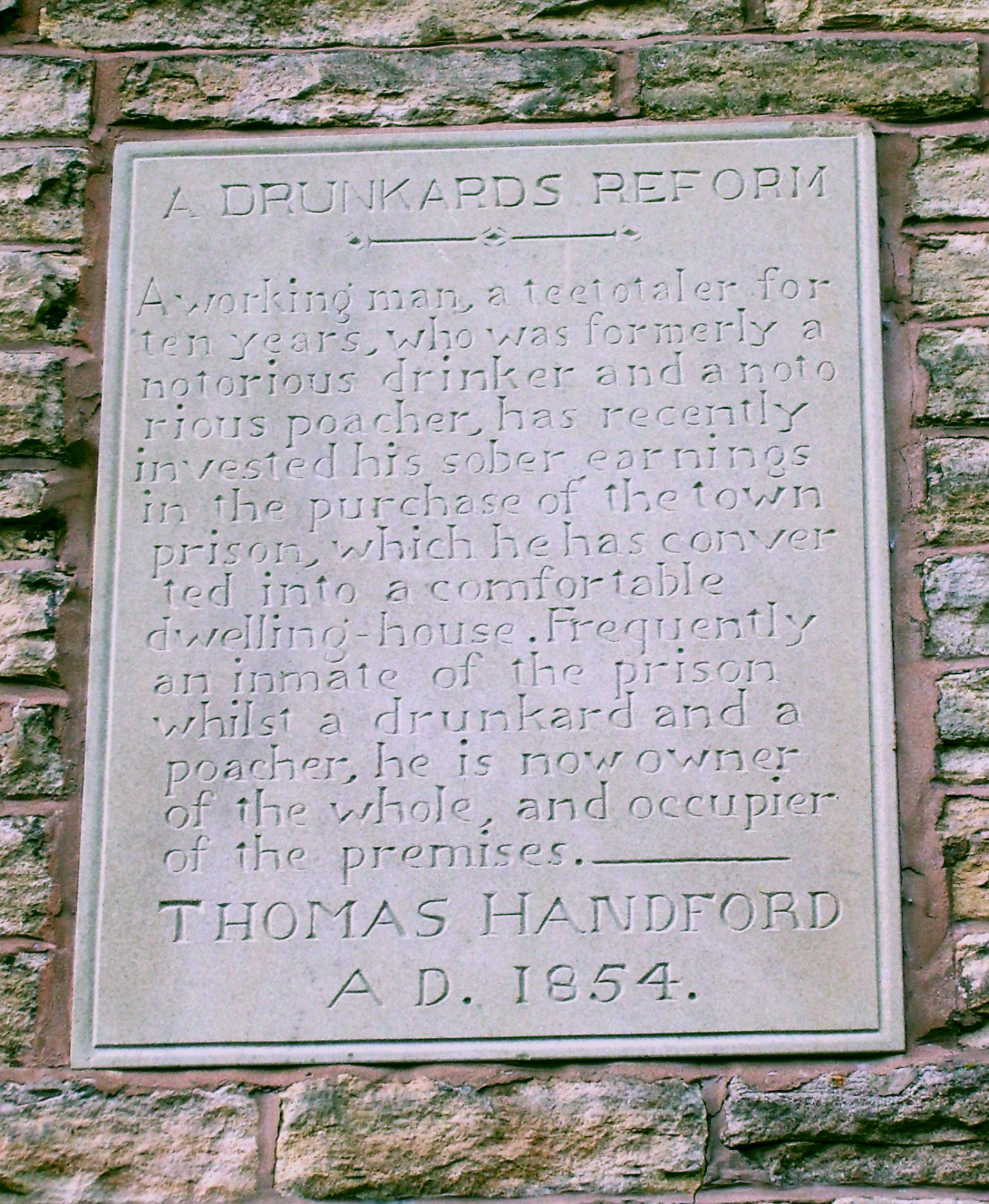 The last house in the row of cottages on Dyehouse Lane is known as the "Drunkard’s Reform". It was formerly the town’s meeting house and later became the town gaol. The stone tablet tells the story of Thomas Handford, a notorious drunkard frequently incarcerated in the gaol. He became teetotal after a fellow drinker fell dead in the Cock Inn. In 1854 he bought the gaol and converted it into his residence. The building was renovated in 1984 and the original tablet over the doorway, after conservation, placed on display in the heritage centre. The tablet here is a replica. The last house in the row of cottages on Dyehouse Lane is known as the "Drunkard’s Reform". It was formerly the town’s meeting house and later became the town gaol. The stone tablet tells the story of Thomas Handford, a notorious drunkard frequently incarcerated in the gaol. He became teetotal after a fellow drinker fell dead in the Cock Inn. In 1854 he bought the gaol and converted it into his residence. The building was renovated in 1984 and the original tablet over the doorway, after conservation, placed on display in the heritage centre. The tablet here is a replica.
The bridge over the river Sett is the oldest river crossing point in New Mills. A duchy of Lancaster corn mill was recorded here in 1391. Sometime later it was rebuilt, becoming known as the "new mill", and a small bridge must have existed then.. It remained no more than a packhorse bridge for centuries and even in 1815 was only four feet wide. It has been altered and rebuilt many times, particularly after a disastrous flood in 1930. It has a separate arch for a former tailrace. The corn mill has been demolished but the present garage buildings were formerly a cotton mill (from the 1790s) and from the late 1880s a chemical works, when it became known as Salem Mill. Note the cottages with their date stone 1856 and initials J.S. (Joseph Stafford, who owned the mill). There was a dye house near here in the eighteenth century, hence Dyehouse Lane.
16. Walk back up High Street a short distance and take the steps to the public footpath on your right. Follow the wooden fence up the path and turn left at the top onto Spring Bank. Follow the road until you come to the Millennium Viewing Point.
This viewpoint provides a wonderful panorama of the western fringe of the 'dark peak' stretching from the plateau of Kinder Scout in the north, rising to 2000 ft., to Combs Moss in the south. In the centre, Ollersett and Beard Moors rise up to the horizon.
Opposite is the Adult Community Education Centre, housed in a handsome stone building of 1878, one of four Board Schools built in the New Mills district following the Education Act of 1870. In this building the first science day school in Derbyshire was established in 1889 and, following the 1902 Education Act, the building became New Mills County Secondary School. The Head was J A Nichols, later the first Head of New Mills Grammar School on Church Lane. Note the wording in relief 'Mackie Memorial Library' This was New Mills first library established by Mrs Mary Mackie in memory of her husband who died in 1891. The books later became part of New Mills Library.
To the right of the former school is the Church of St James and its attractive almshouses, excellent examples of late Victorian architecture of the 1880s. In yet another example of local initiative for which the town is noted, a Trust and Friends group is developing the church into an art centre, and saving it for posterity.
17. After surveying the surrounding countryside, continue along the road before
Higher up High Street on the left, the former Manchester and County Bank with a date stone 1862 on the fine doorway is an example of some of the notable public buildings erected in New Mills in the second half of the nineteenth century as the town’s commerce grew. After being derelict for several years it was repaired and renovated with the help of the New Mills Conservation Area Partnership.
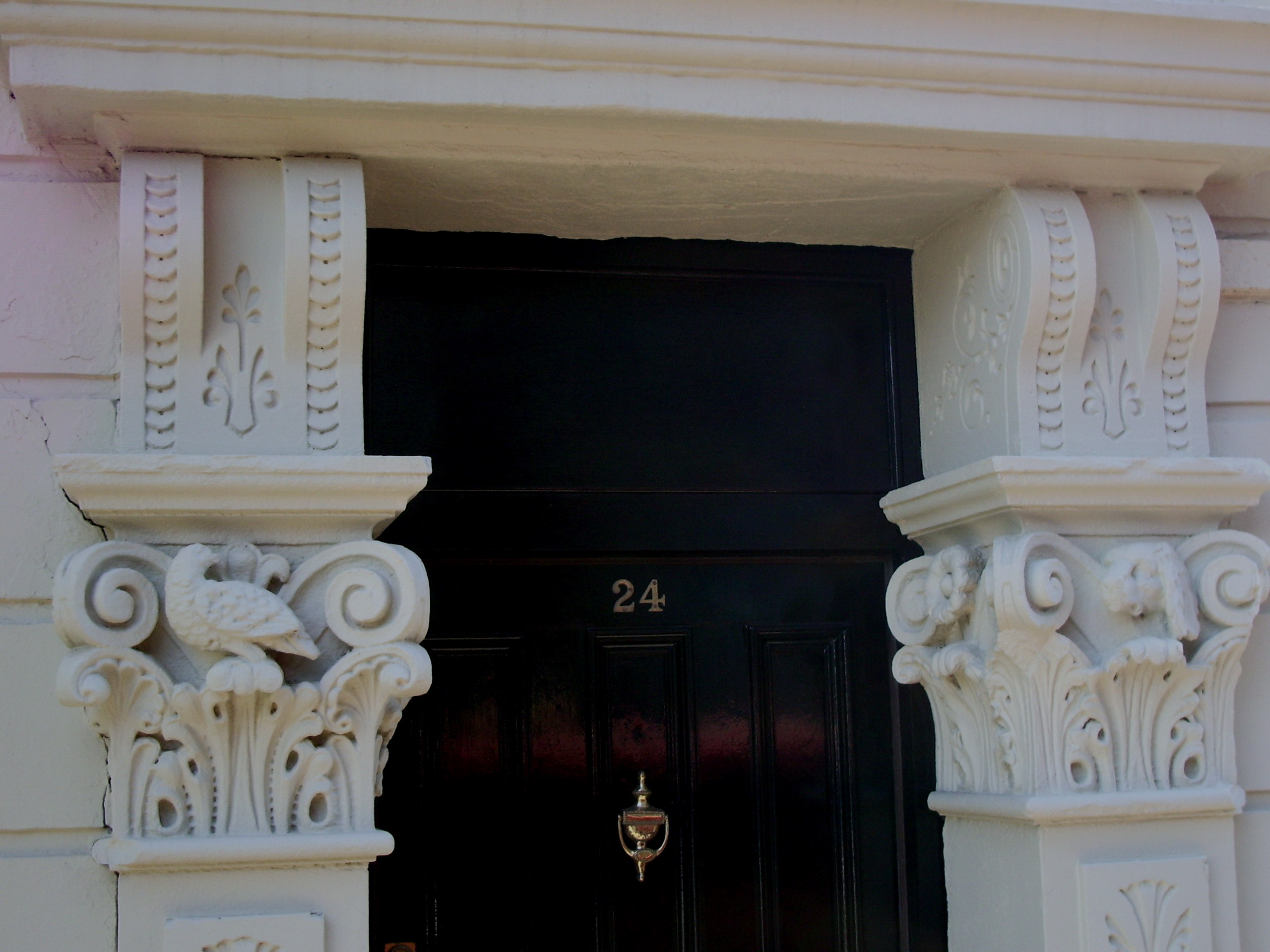 A little further on, the former Dog and Partridge pub (No 24) can be recognised from the carvings on each side of the doorway. It replaced the Mason’s Arms further down High Street as the terminus for the "Mercury" coach. A little further on, the former Dog and Partridge pub (No 24) can be recognised from the carvings on each side of the doorway. It replaced the Mason’s Arms further down High Street as the terminus for the "Mercury" coach.
Beyond, two cottages with their original doorways and stone flag roofs are fine relics of the houses built along this part of High Street in the early 1800s. Note the elaborate monogram "B" and date stone 1808. The houses were built soon after Market Street, a turnpike road, was built to carry on down High Street. Note that some of the shops fronts here appear to be original. Opposite, is the former Co-operative building with two round plaques high up, showing the date 1899. On the Market Street frontage is a beehive.
18. At the end of High Street, turn right up the hill and stand in front of the Town Hall.
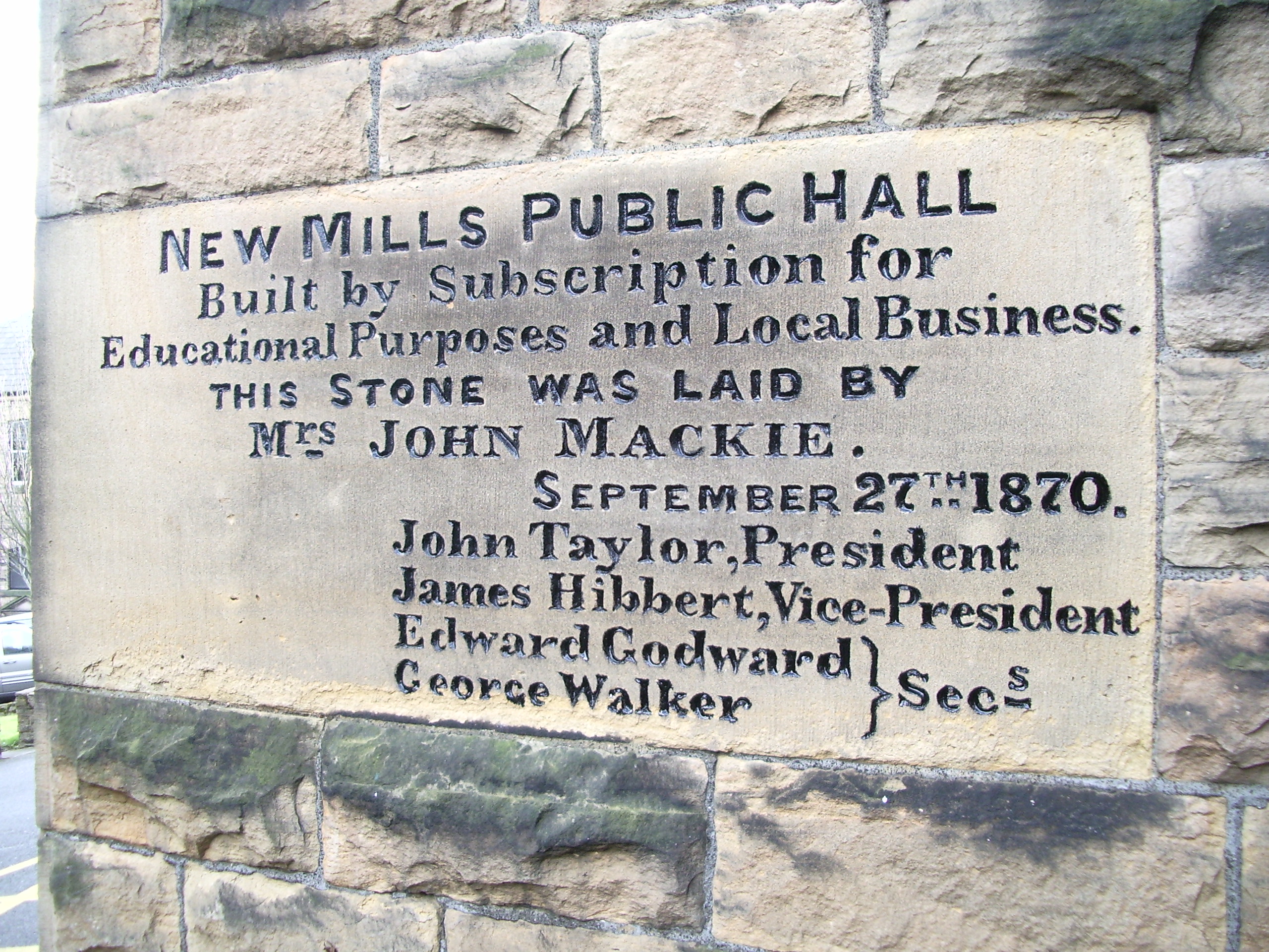 The idea of erecting a public hall by subscription had first been mooted in the town in 1859, but it was 12 years before sufficient money had been collected. It was opened in 1871 and soon became used for a variety of purposes described at the time as "public and private balls, dinners, concerts, entertainments, exhibitions, religious, social and political meetings, for county and sessional courts, library and reading rooms used by the Mechanics Institution, Savings Bank (open on Saturdays only), Local Board offices and the branch offices of the clerk to the magistrates and registrar of the county court." The tower, clock and chimes were added in 1875. In 1895, the hall was transferred to the New Mills Urban District Council, and later became known as the Town Hall. New chimes were donated in 1939. In 1991, as part of the New Mills 600 celebrations, floodlighting was installed, and a new access allowing a direct level route into the first floor main hall was added at the rear in 1995. Note the disused drinking fountain at the front, a memorial to Mr John Mackie, one of many fine men who gave years of devoted voluntary service to the town. The idea of erecting a public hall by subscription had first been mooted in the town in 1859, but it was 12 years before sufficient money had been collected. It was opened in 1871 and soon became used for a variety of purposes described at the time as "public and private balls, dinners, concerts, entertainments, exhibitions, religious, social and political meetings, for county and sessional courts, library and reading rooms used by the Mechanics Institution, Savings Bank (open on Saturdays only), Local Board offices and the branch offices of the clerk to the magistrates and registrar of the county court." The tower, clock and chimes were added in 1875. In 1895, the hall was transferred to the New Mills Urban District Council, and later became known as the Town Hall. New chimes were donated in 1939. In 1991, as part of the New Mills 600 celebrations, floodlighting was installed, and a new access allowing a direct level route into the first floor main hall was added at the rear in 1995. Note the disused drinking fountain at the front, a memorial to Mr John Mackie, one of many fine men who gave years of devoted voluntary service to the town.
19. Walk up Hall Street to the library.
In 1899, a free library, with the aid of a £500 donation from Mr John Hibbert, was opened by the Council in an extension to the Town Hall. This soon proved too small and the present public library building was built in 1909-10with the aid of £2000 from the Carnegie foundation. In 1967 the library was taken over by the County Council.
Opposite the library is the former police station. The town’s original lock-up was on Dyehouse Lane (the "Drunkard’s Reform"), but once this was closed in the 1850s the town did not get a police station until the early 1870s. In 1993, after being described as "the worst police station in Derbyshire", it was relocated to Hurst Lea House, at the bottom of Union Road, and the present building was converted to a residence. A covenant requires the owners to retain the lettering "Constabulary". A plaque also records that Benny Rothman and others were imprisoned here after the "Kinder Trespass" in 1932.
20. Return to the bottom of Hall Street and turn right down Market Street
Market Street originated as a direct extension of a new turnpike road from Marple and was built across the open fields about 1803. Many of the buildings were originally houses and although the new road seems to have been named Market Street by 1830, even by 1841 there were not many shops. This was to change in the second half of the nineteenth century as it became the major shopping area of the rapidly growing new town. For several years after about 1830 the only public house on Market Street was The Crown, now The Torrs. It stands today next to the indoor market (rebuilt in the 1870s). The upper level of the market (at the rear) was built in 1911 as a cinema called the "Picturedrome", surely a very early example of a purpose built cinema.
Today, Market Street has a range of shops and cafes carrying on the tradition of small independent traders catering for the needs of the community. This now lies at the heart of the Conservation Area, grants from which have resulted in several shops having the old Victorian frontages reinstated.
21. Continue along Market Street and at the mini roundabout turn left into Union Road.
Union Road was built across fields in 1884. Near where the Heritage Centre is now, there stood Torr Top Hall which was demolished to make way for the new road, a matter of controversy at the time. Surprisingly, seven years after the road was opened it was still relatively empty of buildings. There were only six houses (the present Jubilee Buildings dated 1887) at the top of the road, the former Conservative Club building (1887) and, at the bottom, Hurst Lea House, now the police station, By the end of the century however, terrace houses and shops lined the road which became an important extension to the commercial part of the town.
 |